
Tree Inventory/Mapping Software

SprigOfTheLivingDead

Almost Self-Reliant
Joined
Jan 18, 2019
Messages
175
Reaction score
215
Points
117
Location
MN - Zone 4b
Anyone try mapping/inventory or planning out tree locations for your property via some mapping software on your phone or a tablet?

Looking to see if there's something else out there for home/farm owners that isn't heavy into arboriculture with 95 points of interest to track per tree. I might be completely overthinking this but just trying to get some others' experiences. I've used Google Maps, just seeing if someone has used something else that was useful for them
 
You kind of lost me there boss. You could get a good reading of each tree on your property by using a gps device and manual identifcation . Oh look this one is a maple, red oak, beech, gum, locust, etc. Then plot them out on a map. Not sure why you would want to do all this work, but it could be done I reckon. What's the end goal?
 
You kind of lost me there boss. You could get a good reading of each tree on your property by using a gps device and manual identifcation . Oh look this one is a maple, red oak, beech, gum, locust, etc. Then plot them out on a map. Not sure why you would want to do all this work, but it could be done I reckon. What's the end goal?
Just seeing if someone has found a rather easy software to approach that.

All my property used to be farmland but the previous owners did plant black walnut, honey locust, birch, silver maple and amur maple. I'm looking to cut down a lot of the amur maple over time and restore the prairie in sections as well as planting a ton of native deciduous trees. Was just curious if people had found good software to help with that so I'm not just printing out a Google map off my property, tacking it to a wall and putting colored pins in it for trees. I'm fine with that but it'd be nice if I could bring up something on my phone that was easy to interact with besides a personal map on Google Maps
 
Just seeing if someone has found a rather easy software to approach that.

All my property used to be farmland but the previous owners did plant black walnut, honey locust, birch, silver maple and amur maple. I'm looking to cut down a lot of the amur maple over time and restore the prairie in sections as well as planting a ton of native deciduous trees. Was just curious if people had found good software to help with that so I'm not just printing out a Google map off my property, tacking it to a wall and putting colored pins in it for trees. I'm fine with that but it'd be nice if I could bring up something on my phone that was easy to interact with besides a personal map on Google Maps
When I was doing small scale logging, property owners would tie a red ribbon around the trees, they wanted to keep. No ribbon means you can harvest it.
 
When I was doing small scale logging, property owners would tie a red ribbon around the trees, they wanted to keep. No ribbon means you can harvest it.
HAHA. I tried to get my wife to help with doing that for amur maple. She was not enthused.

I was thinking about just cutting branches and spray painting the end few inches different colors depending on the desired species and pounding that into the ground where I wanted a type of tree. Problem is I already tried that with marking the property line in one spot and, well, when you call attention to a stick/branch like that that is stuck in the ground your children are destined to notice it and yank it out to go beat against another tree, use as a magic wand, sword or whatever the hell kids do with stuff you didn't want them to pay attention to

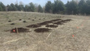
Just trying to mark where I'm augering holes for my tree farm is a coin flip as to if those flags will be there in a week, considering our 3 year old's attention.
 

Attachments

  • holes.jpg
    holes.jpg
    242.2 KB · Views: 498
HAHA. I tried to get my wife to help with doing that for amur maple. She was not enthused.

I was thinking about just cutting branches and spray painting the end few inches different colors depending on the desired species and pounding that into the ground where I wanted a type of tree. Problem is I already tried that with marking the property line in one spot and, well, when you call attention to a stick/branch like that that is stuck in the ground your children are destined to notice it and yank it out to go beat against another tree, use as a magic wand, sword or whatever the hell kids do with stuff you didn't want them to pay attention to

Just trying to mark where I'm augering holes for my tree farm is a coin flip as to if those flags will be there in a week, considering our 3 year old's attention.

Nice black dirt... It's almost a shame to waste it on tree roots. Trees only need 3/3/3, anymore than that is a waste.
 
What kind of information are you looking to track on the trees? Not sure what your goal is for tracking - tree sales?
 
What kind of information are you looking to track on the trees? Not sure what your goal is for tracking - tree sales?
no, this is for personal trees around the property. It's more just about landscape planning as I choose what should go where as I'm restoring prairie land and choosing placement for trees.
 
no, this is for personal trees around the property. It's more just about landscape planning as I choose what should go where as I'm restoring prairie land and choosing placement for trees.

So just a natural native space then? I have like a billion red maple seeds, I blow them off the walks constantly this time of the year.
 
So just a natural native space then? I have like a billion red maple seeds, I blow them off the walks constantly this time of the year.
Yep. Ha. I'm planting Catalpa, Willow, poplar, oaks, kentucky coffee, buckeye, sycamore, hickory and others.

I'm fine using methods I have been, but I was just curious if someone else highly suggested a piece of software that they've used for a similar purpose.

There's obviously things like ArcGIS, but that's more for really mapping our bigger environmental lands, interfacing with your GPS devices and allowing you to collaborate with your biotech and environmental scientists. Overkill.
 
Back
Top